


Hong Kong Charts (HK)
")
Availability: By Request
In the context of navigational safety, the Hong Kong Hydrographic Office (HKHO) has taken on a role primarily as provider of nautical information for port users. To achieve this, the HKHO carries out hydrographic surveys continually to gather relevant data which include water depths and seabed nature. Together with other navigational information, up-to-date nautical charts and publications are produced for port users.
Bilingual (Chinese and English) paper nautical charts are produced in accordance with the specifications of the International Hydrographic Organization (IHO). The positions on the chart are referred to the WGS84 Datum. The depths are in metres and reduced to the Chart Datum, which is approximately the Lowest Astronomical Tide. The buoyage system in Hong Kong follows the IALA Maritime Buoyage System (Region A), i.e. Red to Port, Green to Starboard.
The nautical charts are in five different scales according to their coverage (see below) and usage
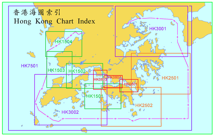
| Chart | |
| Chart No | Scale 1:8000 Series HK0801 - Harbour - Eastern Part [海港東部] HK0802 - Harbour - Central Part [海港中部] HK0803 - Harbour - Western Part [海港西部] Scale 1:15000 Series HK1501 - Lamma Channels [博寮海峽] HK1502 - Ma Wan And Approaches [馬灣及臨近水域] HK1503 - Urmston Road [龍鼓水道] HK1504 - Deep Bay [后海灣] Scale 1:25000 Series HK2501 - Port Shelter [牛尾海] HK2502 - South Eastern Approaches [東南臨近水域] Scale 1:30000 Series HK3001 - Mirs Bay [大鵬灣] HK3002 - South Western Approaches [西南臨近水域] Scale 1:75000 Series HK7501 - Hong Kong Waters [香港水域] |